Marine GPS Chartplotters
-
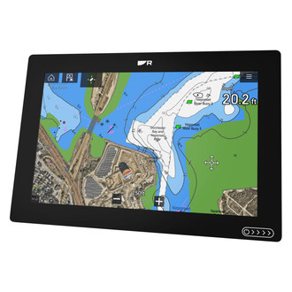
 Raymarine®Axiom+ 12 12.1" GPS Chartplotter with Lighthouse North America Charts w/o Transducer (E70638-00-102)Axiom+ 12 12.1" GPS Chartplotter with Lighthouse North America Charts without Transducer (E70638-00-102) by Raymarine®. The performance-tuned Axiom®+ is a new generation of award-winning Raymarine multifunction displays. Optimized for...Fluid and fast chart redraw of LightHouse, Navionics, and C-MAP electronic chartsPowerful quad-core processor, plus increased onboard storage for personal data and apps$2,888.99
 - Raymarine®Axiom+ 7 7" GPS Chartplotter with Basemap w/o Transducer (E70634)Axiom+ 7 7" GPS Chartplotter with Basemap without Transducer (E70634) by Raymarine®. The performance-tuned Axiom®+ is a new generation of award-winning Raymarine multifunction displays. Optimized for speed, Axiom Plus is equipped with...Fluid and fast chart redraw of LightHouse, Navionics, and C-MAP electronic chartsPowerful quad-core processor, plus increased onboard storage for personal data and apps$855.99
- Raymarine®Axiom+ 7 7" GPS Chartplotter with Lighthouse North America Charts w/o Transducer (E70634-00-102)Axiom+ 7 7" GPS Chartplotter with Lighthouse North America Charts without Transducer (E70634-00-102) by Raymarine®. The performance-tuned Axiom®+ is a new generation of award-winning Raymarine multifunction displays. Optimized for...Fluid and fast chart redraw of LightHouse, Navionics, and C-MAP electronic chartsPowerful quad-core processor, plus increased onboard storage for personal data and apps$909.49
- Raymarine®Axiom+ 7 7" GPS Chartplotter with Navionics+ North America Charts w/o Transducer (7063400NAG)Axiom+ 7 7" GPS Chartplotter with Navionics+ North America Charts without Transducer (7063400NAG) by Raymarine®. The performance-tuned Axiom®+ is a new generation of award-winning Raymarine multifunction displays. Optimized for speed,...Fluid and fast chart redraw of LightHouse, Navionics, and C-MAP electronic chartsPowerful quad-core processor, plus increased onboard storage for personal data and apps$1,059.73
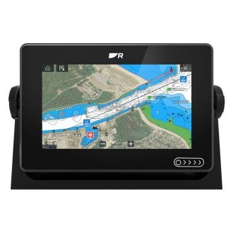
- Raymarine®Axiom+ 9 9" GPS Chartplotter with Lighthouse North America Charts w/o Transducer (E70636-00-102)Axiom+ 9 9" GPS Chartplotter with Lighthouse North America Charts without Transducer (E70636-00-102) by Raymarine®. The performance-tuned Axiom®+ is a new generation of award-winning Raymarine multifunction displays. Optimized for...Fluid and fast chart redraw of LightHouse, Navionics, and C-MAP electronic chartsPowerful quad-core processor, plus increased onboard storage for personal data and apps$1,337.49
- SI-TEX®SVS-1010 10.1" GPS Chartplotter with Navionics Gold North American Charts and External GPS Antenna (SVS-1010CE)SVS-1010 10.1" GPS Chartplotter with Navionics Gold North American Charts and External GPS Antenna (SVS-1010CE) by SI-TEX®. This product is made of high-quality materials to serve you for years to come. Designed using state-of-the-art...Engineered to high standardsHigh-grade design delivers extended lifespan$1,765.50
- SI-TEX®SVS-1010 10.1" GPS Chartplotter with Navionics Gold North American Charts and Internal GPS Antenna (SVS-1010C)SVS-1010 10.1" GPS Chartplotter with Navionics Gold North American Charts and Internal GPS Antenna (SVS-1010C) by SI-TEX®. This product is made of high-quality materials to serve you for years to come. Designed using state-of-the-art...Engineered to high standardsHigh-grade design delivers extended lifespan$1,699.37
- SI-TEX®SVS-460 4.3" GPS Chartplotter with Navionics Gold North American Charts and External GPS Antenna (SVS-460CE)SVS-460 4.3" GPS Chartplotter with Navionics Gold North American Charts and External GPS Antenna (SVS-460CE) by SI-TEX®. This product is made of high-quality materials to serve you for years to come. Designed using state-of-the-art...Engineered to high standardsHigh-grade design delivers extended lifespan$679.18
- SI-TEX®SVS-460 4.3" GPS Chartplotter with Navionics Gold North American Charts and Internal GPS Antenna (SVS-460C)SVS-460 4.3" GPS Chartplotter with Navionics Gold North American Charts and Internal GPS Antenna (SVS-460C) by SI-TEX®. This product is made of high-quality materials to serve you for years to come. Designed using state-of-the-art...52-channel GPS w/standard internal antenna (optional external antenna)"Dual fuel" charting with C-MAP and Navionics cartography$613.05
- SI-TEX®SVS-560 5" GPS Chartplotter with Navionics Gold North American Charts and External GPS Antenna (SVS-560CFE)SVS-560 5" GPS Chartplotter with Navionics Gold North American Charts and External GPS Antenna (SVS-560CFE) by SI-TEX®. This product is made of high-quality materials to serve you for years to come. Designed using state-of-the-art...Engineered to high standardsHigh-grade design delivers extended lifespan$868.10
- SI-TEX®SVS-560 5" GPS Chartplotter with Navionics Gold North American Charts and Internal GPS Antenna (SVS-560CF)SVS-560 5" GPS Chartplotter with Navionics Gold North American Charts and Internal GPS Antenna (SVS-560CF) by SI-TEX®. This product is made of high-quality materials to serve you for years to come. Designed using state-of-the-art...Engineered to high standardsHigh-grade design delivers extended lifespan$801.98
- SI-TEX®SVS-760 7.5" GPS Chartplotter with Navionics Gold North American Charts and Internal GPS Antenna (SVS-760C)SVS-760 7.5" GPS Chartplotter with Navionics Gold North American Charts and Internal GPS Antenna by SI-TEX®. This product is made of high-quality materials to serve you for years to come. Designed using state-of-the-art technology and...20,000 marks/waypoints100 routes$896.44
- SI-TEX®SVS-880 8" GPS Chartplotter with Navionics Gold North American Charts and External GPS Antenna (SVS-880CE)SVS-880 8" GPS Chartplotter with Navionics Gold North American Charts and External GPS Antenna (SVS-880CE) by SI-TEX®. This product is made of high-quality materials to serve you for years to come. Designed using state-of-the-art...Engineered to high standardsHigh-grade design delivers extended lifespan$1,198.72
- SI-TEX®SVS-880 8" GPS Chartplotter with Navionics Gold North American Charts and Internal GPS Antenna (SVS-880C)SVS-880 8" GPS Chartplotter with Navionics Gold North American Charts and Internal GPS Antenna (SVS-880C) by SI-TEX®. This product is made of high-quality materials to serve you for years to come. Designed using state-of-the-art...Engineered to high standardsHigh-grade design delivers extended lifespan$1,132.60
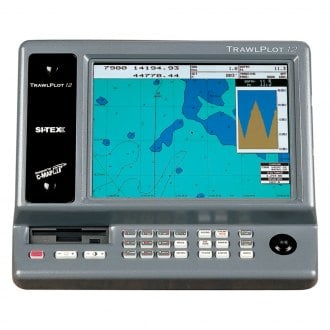
- SI-TEX®Trawl Plot 12" GPS Chartplotter w/o Charts (TRAWLPLOT 12 SD)Trawl Plot 12" GPS Chartplotter without Charts (TRAWLPLOT 12 SD) by SI-TEX®. This product is made of high-quality materials to serve you for years to come. Designed using state-of-the-art technology and with customers in mind. It will...12.1" XVGA Color LCD TFT display with 800 x 600 pixels for high-definitionGPS WAAS 18-channel receiver will put your boat within 3 meters of your waypoint in most situations$2,643.99
- SI-TEX®Trawl Plot 12" GPS Chartplotter w/o Charts (TRAWLPLOT 12)Trawl Plot 12" GPS Chartplotter without Charts (TRAWLPLOT 12) by SI-TEX®. This product is made of high-quality materials to serve you for years to come. Designed using state-of-the-art technology and with customers in mind. It will meet...12.1" XVGA Color LCD TFT display with 800 x 600 pixels for high-definitionGPS WAAS 18-channel receiver will put your boat within 3 meters of your waypoint in most situations$2,697.96


Marine GPS chartplotters are widely used in sea navigation to integrate electronic navigational charts and GPS data, which allows for viewing the real-time position, speed, and heading of the vessel on the screen. However, these smart electronic devices are not the same, and their prices greatly differ depending on their functionality. As the cost goes up, you can choose a larger screen (or touchscreen), higher resolution, faster processor, model with an internal sonar, ability to connect a radar, WiFi function, compatibility with NMEA 2000 network, and so on. Many models are offered as combos incorporating the functions of fishfinders, GPS, radars, etc. in a single module.
In our online store, you can select a GPS chartplotter that suits you best. There are handheld and fixed-mount models with or without charts, which have been presorted in accordance with their resolutions. Many of them can also receive GLONASS and Galileo data, show information from the radar, and support such systems as AIS or DSC that can be used to minimize the risk of collisions and accidents in inclement weather or at night. All of them are sourced from reputable brands such as Garmin, Lowrance, Raymarine, and others.