
Here are some suggestions that could solve the problem and prevent you from having to be without your unit!
- Mapping Problems
- Depth Reading Problems
Accuracy
Lowrance Electronics obtains its mapping data from government agencies. Mapping is not an exact science. A unit's GPS position (Latitude/Longitude) can be extremely accurate, but the location of a cartographic item such as a street, highway, or point-of-interest may be slightly inaccurate. In most cases, Lowrance have found the mapping detail in their products to be very accurate.
Lowrance encourages the reporting of inaccuracies or omissions so that the company can consider them for future revisions. Please consider that Lowrance products are designed to be aids to navigation and not the sole means of navigation. A prudent navigator will also have several items necessary for safe navigation.Expectation
It is almost impossible for any mapping agency to keep up with the changes and additions that occur. Roads or highways that you know have been around for a some time, may still not be a part of the database provided with Lowrance products. Again, Lowrance encourages the reporting of these items so that they can be considered for future revisions.Cards are not Read by the Unit
Before purchasing a pre-loaded mapping card for a unit look at the list of units that are compatible with that card.
- If the card is not recognized by the unit, make sure the card contacts and corresponding unit pins are clean and free of obstructions. Verify that the card is securely seated in the card port.
- Try resetting the unit as described below.
- If it is a card for a MapCreate map or saved GPS data, it may need to be formatted. Do not format pre-loaded cards such as Insight, Nautic-Path, Fishing Hot Spots Pro, Lake Master Pro, Freedom Maps, or Navionics. The information will be deleted from the card.
Please be aware that Lowrance GPS products will only read cards that are FAT formatted. MMC cards formatted using FAT 32 or NTFS will not work with Lowrance products.Current Position not on the Screen
First, make sure the unit is locked onto the satellites and shows a fix on the satellite status screen. Then check for cross-hairs on the screen (or for an automotive unit, a red box with an X). If this is on the screen, it means that you had pressed one of the arrow buttons. When that is done, the unit thinks that you want to scroll to a location on the screen or zoom in or out to see more detail. Simply press the EXIT button to clear the cross-hairs and your current position will now be shown in the middle of the display.
For an automotive unit, press the red box with the X in it to return to your current position.Update the Software
Make sure your unit has the latest software version. The Lowrance updates are free.Reset the Unit
Sometimes resetting your unit can solve unusual issues. Try a Soft Reset first, this will return your settings to factory defaults.
If you decide to try a Hard Reset, save any important stored data to an MMC or SD card or write the information down. The data will be deleted during this process.Losing depth when the boat is moving
This is likely due to cavitation (turbulence) in the water surrounding the transducer. You may need to move the transducer lower in the water or to another location. The transducer cannot send or receive signals through air bubbles.Losing depth in shallow water
It can sometimes be difficult for a high-powered unit to capture the lightning-fast return in shallow water. Turn off the automatic sensitivity setting and manually reduce the sensitivity until the unit locks onto the bottom.Losing bottom over weeds
When trolling over weed beds in 20' of water or less, you may experience vertical bars, loss of the chart picture, or the digital depth. First, do a soft reset of the unit. Then go to the Full Sonar Chart screen. Press Menu and select Sonar Features. Now turn the Chart Manual Mode to On. This will leave everything in Automatic Mode except the depth. Now go back to the main menu and set the depth range for the depth you are in such as 0-20 feet.Losing depth when another sonar unit is on
If two or more sonar units using the same transducer frequency are operating at the same time, one or more of them may lose the depth reading to the interference. It is like two radio stations trying to both broadcast on 97.3FM. In shallow water, if the transducers are far enough apart, you may be able to operate them together. However, the deeper the water, the wider the beams spread out. When they cross each other, the interference occurs.No depth reading at any time
Clean the bottom of the transducer. Make sure the beam is shooting down (see picture below). Check your transducer connection to the back of the unit. Check the connector pins for corrosion. Check the cable for frayed or pinched areas.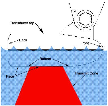
Phone a friend
If a friend has the same transducer and power connection on their boat, try your unit on their cables. If your unit works on the other boat, you transducer may need to be replaced.